- Skip Navigation
- Home
- Amusements
- Art
- Camps
- Facts
- 2nd Railroad in the U.S.
- Elvis was in the building...
- It wasn't originally the Bali Hai
- Jazz was born and bred on the Lake
- Longest continuous curve on U.S. rails
- Over 125 species of fish
- Submarine Races?
- The $10,000 fish
- The first movie in New Orleans
- The shortest-lived rail ferry services in Louisiana
- Women Lighthouse Keepers
- World's Longest Bridges
- Y.M.G.C. ROWING CLUB
- Get the Pictures
- History
- Hurricanes
- Landmarks
- 1832 to present, Milneburg Light (also known as the Port Pontchartrain Light)
- 1832-1950s - New Basin Canal
- 1833 to present, St. Charles Avenue Streetcar Line - An ASME Historic Mechanical Engineering Landmark
- Bayou St. John
- Pitot House -- National Register of Historic Places
- Pointe Aux Herbes Lighthouse
- The Camps
- Literature
- 1841 - The Magnolia of Lake Pontchartrain
- 1852 - Uncle Tom's Cabin
- 1863 - CLARIMONDE: A TALE OF NEW ORLEANS LIFE, AND OF THE PRESENT WAR BY A MEMBER OF THE N. O. WASHINGTON ARTILLERY.
- 1874 - Life On the Mississippi
- 1879 - Four Months in a Sneak-Box
- 1894 - A LADY OF BAYOU ST. JOHN
- 1894 - La Belle Zoraide
- 1897 - A Night in Acadie
- 1897 - Athénaïse
- 1899 - The Goodness of St. Rocque
- 1912 - Social Life in Old New Orleans,
- 1920's & 30's - Mosquitoes and Pylon
- 1946 - Lake Pontchartrain
- 2000 - Crossing Border Street
- Maps
- Military
- Music
- Neighborhoods
- Other N.O. Sites
- The French Quarter's People and Places
- The Nostalgic New Orleans Collection
- Get the Pictures
- Volume 1-ABC
- Volume 2-DEF
- Volume 3-GHI
- Volume 4-JKL
- Volume 5-MNO
- Volume 6-PQR
- Volume 7-STU
- Volume 8-VWX
- Volume 9-YZ
- Contributors
- Lake History
- The Yat Map
- Links
- What is this?
- The Best
- Now & Then
- Feb-Mar
- Today in History
- The 60s
- Art Trivia
- 1879 Illustration from The Nathanial Bishop book Four Months in a Sneakbox.
- Dis is
- Dis is da jacket covuh faw a Robert Tallant book.
- Dis sculptcha is cawled
- Franck Schneider painted this portrait c. 1920s based on an earlier painting by George Catlin.
- Here is an illustration of West End from a book published in 1874.
- Here's a very famous painting of the New Orleans Cotton Exchange in 1873,
- Here's an illustrations called 'WINTER IN THE SOUTH' - for an article in HARPER'S NEW MONTLY MAGAZINE, December 1858.
- High above the Reception Desk, enthroned in a leafy bower, Rex, King of the Carnival and Monarch of Merriment, greets his loyal
- I love this gigantic clarinet. Where is it?
- Illustration from a book published in 1852:
- Krewe of Proteus Float Design circa 1905
- Multicolored Lotus circa 1920 watercolor
- One of my favorite murals in the city. Artist--Tony Green. Where is this?
- The New Orleans Museum of Art is located in City Park at One Collins C. Diboll Circle.
- This sculpture is called 'Serpent Mound'
- This statue is in a New Orleans church. Who's da saint and name da Church?
- This statue, designed by Enrique Alferez, was installed in 1988 on Magazine Street.
- Today we look at some sheet music awt:
- What is this building, where is it located, and what was its' original name?
- Which local hotel is pictured and which artist is featured?
- Who illustrated
- Mr. Lake's Forum
- N. O. Trivia
- A well known writer who came to New Orleans in 1877 was known as 'A Lapidary in Words'
- In May of 1907 Charles C. Mathews opened an amusement park here in the City of New Orleans.
- In May of 1907 Charles C. Mathews opened an amusement park here in the City of New Orleans.
- Joseph Vaccaro, born in Contessa Entellina, Sicily (my own ancestors' stompin' grounds) moved with his parents
- many years ago when something was done backwards, it was colloquially referred to as the 'Belmont Way'. Why
- On March 15, 1729 a ceremony was held for Sister Stanislas Hachard at the Ursuline Convent here in New Orleans.
- This local musician and songwriter secured his place in New Orleans music history with his one and only hit.
- What did it mean when the Falstaff weather ball was flashing red and white?
- What does the word "Tchoupitoulas" mean?
- What is the origin of the word 'stoop'?
- What item was commonly used to scrub stoops in New Orleans?
- What wuzza "TIX Tenna Topper"? Ya hafta git da color an na shape right
- When we think of female movie stars of long ago who hailed from Noo Awlins, we usually think Dorothy Lamour.
- Where was the Third District Ferry landing located?
- Which Roosevelt was the hotel named after?
- Zydeco is an accordian based combination of traditional sounds with rhythm and blues elements.
- Today in New Orleans History
- August 18, 1988 Republican National Convention in the Super Dome
- 1800 Oct. 1, Spain ceded Louisiana to France in a secret treaty.
- 1802 Apr 19, Spain reopened the New Orleans port to American merchants.
- 1803 Dec 20, The Louisiana Purchase was completed
- 1803 Dec 30, The United States took possession of the Louisiana area from France at New Orleans
- 1803- American troops arrive in New Orleans.
- 1803 Declaration...the town of Bayou St. John shall be a port of delivery
- 1803 New Orleanians Become Americans
- 1804 Louisiana Purchase was divided into Territories of
- 1804 - The first English language newspaper in New Orleans
- 1805 Jul 25, Aaron Burr visited New Orleans with plans to establish a new country, with New Orleans as the capital city.
- 1806 Andrew Jackson Duel
- 1806 Norbert Rillieux is Born
- 1812 Louisians Becomes a State
- 1812 The first steamboat arrived in New Orleans
- 1814 - Battle of New Orleans
- 1814 - General Andrew Jackson announces martial law in New Orleans
- 1814 Andrew Jackson Arrives in New Orleans
- 1814 British Use Fireworks in The Battle of New Orleans
- 1814 The Steamboat New Orleans Sinks
- 1815 The Battle of New Orleans
- 1816 -- 1st double decked steamboat, Washington, arrives in New Orleans
- 1816 - Jacques Philippe Villere - Governor
- 1816 The town of Covington is Chartered
- 1818 Garbage Boat
- 1819 Coffee Ad
- 1823 Overcrowded Jails
- 1830 The Pontchartrain Railroad is Chartered
- 1831 - First
- 1831 The Pontchartrain Railroad begins running on what is now the Elysian Fields Avenue neutral ground
- 1832 Schooner Robert Burns Sails to New Orleans
- 1832 The Pontchartrain Railroad
- 1834 Madame Lalaurie's Legend
- 1835 The Medical College of Lousiana Opens--Later Becomes Tulane University
- 1837 A New Jail
- 1839 Debtors Prison
- 1844 - Union Forces Advance toward New Orleans
- 1851 Passenger List
- 1854 The Great State Post Stakes
- 1855 Rematch of at the Metairie Race Track
- 1857 Comus, the god of revelry, became the first New Orleans Mardi Gras parade
- 1860 Fireworks Drive Man Crazy
- 1861 - a
- 1861 - Free Negroes of the City meet and then tender their services to the Confederate Government
- 1862 Gen. Benjamin Beast Butler orders Mrs. Philip Philips imprisoned on Ship Island
- 1862 - Harper's Weekly Illustration
- 1862 - Women's Order
- 1862 Henriette Delille Dies
- 1862 The Capture of New Orleans
- 1862, New Orleans fell to Union forces during Civil War
- 1863 Feux de Joie Aid Confederate Army
- 1863 Governor John M. Parker is Born
- 1864 The New Orleans Tribune, 1st African-American daily newspaper was founded
- 1867 Comus Parade
- 1867 New Orleans dedicated its first synagogue
- 1870 Algiers was annexed as part of New Orleans
- 1870 The New Orleans Pelicans Debut
- 1870 The U.S. governments first simultaneous weather report was made from 23 weather stations across the country-including N.O.
- 1870 Twelfth Night Revelers - 2nd N.O. Carnival Krewe
- 1876 NOLTC is the countrys first lawn tennis club
- 1876 Rayne Memorial United Methodist Church
- 1877 Federal troops were ordered out of New Orleans, ending the North's post-Civil War rule in the South.
- 1878 J. F. Doescher opens Lutheran Sunday school for Negroes
- 1884 Oscar Papa Celestine is born
- 1887 The N.O. The Pelicans make their professional debut
- 1889 - Death of Confederate President Jefferson Finis Davis
- 1889 David C. Hennessey becomes the citys first Superintendent of Police
- 1890 Superintendent of Police, David C. Hennessey is Murdered
- 1892 Sullivan vs Corbett Fight
- 1893 The Longest Prizefight in History
- 1896 Plessy vs. Ferguson
- 1896 First Movie in New Orleans
- 1896 First Movie Theater in the United States
- 1897 Sidney Bechet is Born -- and died on his 62nd Birthday in 1959
- 1897 The Great Steamboat Race
- 1898 - McDonogh Monument is Dedicated
- 1898 Gustave Joseph (Sharkey) Bonano is Born
- 1903 United Confederate Veterans Reunion
- 1909 - Robert Tallant is Born
- 1909 Danny Barker was born
- 1909 Napoleon's Death Mask...
- 1910 - Moisant vs. a Packard
- 1911 - Hubert Humphrey (LSU graduate and Vice-President) is born.
- 1911 Mahalia Jackson is Born
- 1911 Mahalia Jackson was born
- 1912 USS South Carolina in New Orleans
- 1913 Storyville
- 1914 - Dorothy Lamour was Born
- 1914 Kitty Carlisle is born in New Orleans
- 1915 Pelican Stadium Opens
- 1915 Storm
- 1920 The Desire streetcar began operating
- 1921 - 24 ton Hibernia Bank vault door
- 1924 - Lee Dorsey is Born
- 1925 -- Roy James Brown Was Born
- 1925 Pulitzer Brothers Begin a Tie Empire
- 1927 -- Charles Lindbergh, flew the Spirit of St. Louis into Alvin Callender Field
- 1927 Milneburg Camps (now UNO area)
- 1928 The first Pontchartrain Beach at Spanish Fort
- 1928 World's Longest Bridge
- 1929 Streetcar Strike
- 1930 The First Coffee Break
- 1931 First Night Game Played at Tiger Stadium
- 1932 The Smokey Mary makes its' last trip to Milneburg
- 1933 The National Bank of Commerce
- 1934 Lodge No. 30 of the Benevolent and Protective Order of Elks Approve the Idea of a Truck Parade for Mardi Gras
- 1934 Mayor of New Orleans Big Police Force ready to do battle with Senator Huey P. Longs Guardsmen
- 1935 - The Bonnet Carre Spillway is Dedicated
- 1935 - The Huey P. Long Bridge is Dedicated
- 1935 Huey P. Long Bridge Dedication
- 1937 - FDR in New Orleans
- 1937 - Legal documents bound by WPA Bookbinding Project.
- 1937 Lagoon Bridge (City Park)
- 1937 New Orleans Item Political Cartoon,
- 1938 Allen Toussaint was born
- 1938 Fascism or Freedom
- 1939 -- Fire Station #1 at Elysian Fields and Pelopidas St.
- 1939 Robert E. Lee Blvd. Bridge
- 1939 Oretha Castle Haley is Born
- 1940 - St. Mark's Community Center
- 1940 Dr. John (born Malcolm Rebennack, aka Mac Rebennack) is Born
- 1940 Duke Ellington Records Ko-Ko
- 1940 WPA Bookbinding Project
- 1941 Linclon Beach
- 1941 Pontchartrain Beach
- 1941 Pontchartrain Beach
- 1942 Air Raid Warning Truck
- 1944 West End Street Car
- 1946 Chep Morrison Inauguration
- 1948 - WDSU TV Channel 6 in New Orleans begins broadcasting.
- 1948. The Desire Streetcar Ceases Operation
- 1952 De La Salle High School is Officially Dedicated
- 1952 Evarts Ambrose Graham Dies
- 1952 The Falstaff Weather Ball is First Lit
- 1953 Homer Plessy is Born
- 1954 - The new Union Railroad Station opens
- 1954 Oscar
- 1956 - Daniel Mukes, traditional jazz snare drummer from New Orleans, Louisiana died
- 1956 -- John F. Kennedy at the Roosevelt Hotel
- 1956 Lake Pontchartrain Causeway Opens
- 1956 Audubon Park Fishing rodeo
- 1957 Pelican Stadium Closes
- 1960 - Gov. Davis seeks funding for private education
- 1960 - Jimmie Davis is elected governor
- 1960 Jessie Hill recorded Ooh Poo Pah Doo
- 1961 Ernie K-Doe's Mother-In-Law hits the Billboard Charts
- 1961 Imprisonment for debt is abolished legally in Louisiana
- 1962 New Orleans Citizens Committee gave a free one-way ride to blacks to move North.
- 1962 Archbishop Joseph Francis Rummel ordered all Roman Catholic schools in the New Orleans diocese to end segregation.
- 1962 Vic Schiro's Inauguration
- 1963 - Tidelands Officially Deeded
- 1964 - Louis Armstrong hit the top of the pop charts for the first time in his career with
- 1964 Mayor Morrison's Funeral
- 1965 - Joe Rotis, traditional jazz trombonist, dies
- 1967 Mayor Schiro confers with his legislative leaders
- 1967 Saints launched their first season-ticket drive
- 1967 The Notorious Riverfront Expressway
- 1967 Vic Schiro and Alton Ochsner
- 1968 - Christopher 'Black Happy' Goldston, traditional jazz drummer from New Orleans, Louisiana died
- 1968 Scoop Kennedy's Birthday
- 1969 Fire on Oak Street
- 1970 the Doors made their last appearance with Jim Morrison.
- 1971 Louis Armstrong Dies
- 1972 - Lous Saint at WTIX Radio
- 1972 Mahalia Jackson Dies
- 1973 Mardi Gras
- 1976 Times-Picayune Article About Pralines
- 1978 - Harold Cooper died
- 1980 - The New Orleans Saints end their 14 game losing streak
- 1981 Oliver Alcorn Dies
- 1983 Sweet Emma Barrett Dies
- 1989 - Deep Cold in the Deep South
- 1989 - New Orleans native Bobby 'I'm Gonna Be A Wheel Someday' Mitchell passed away at the age of 53, on this day.
- 1989 Professor Longhair (born Henry Roeland Byrd) Dies
- 1993 The Pelican Brief
- 1994 Danny Barker Passes Away
- 1997 Our Mother of Perpetual Help Chapel
- 1997 Termites threaten New Orleans' treasures
- Apr 11, 1713 The French colony of Acadia was ceded to Great Britain
- April 1, 1778 Oliver Pollock created the $ sign
- April 1, 1778 Oliver Pollock created the dollar sign
- April 15, 1958 Greater New Orleans Bridge opening
- April 15, 1958 Greater New Orleans Bridge opening
- April 27, 1999 Al Hirt, Dies
- April 4, 1812 The Territory of Orleans admitted to the Union
- April 4, 1812 The territory of Orleans became the 18th state
- April 8, 1812 Louisiana Territory become Missouri Territory
- April 9, 1682 La Salle discovers New Orleans
- Aug 25, 1718 Hundreds of French colonists arrived in Louisiana
- Aug. 7, 1727 Ursaline Nuns Arrive in New Orleans
- August 4, 1901 Louis Armstrong was born
- August 17, 1969 Hurricane Camille
- August 18, 2000 Dorothy Mae Delavallade Taylor Dies
- August 25, 1718 City of New Orleans founded
- August 25, 1718 City of New Orleans founded
- August 25-26, 1992 Hurricane Andrew
- August 29, 2005 Hurricane Katrina
- August 3, 1975 Superdome (New Orleans) opened.
- Benjamin F. Butler, U.S. Civil War General, died on this day in 1893
- Comic performer Ellen DeGeneres was born on this day in 1958 in New Orleans.
- December 10, 1914 Dorothy Lamour is born .
- December 20, 1802 U.S. purchases Louisiana Territory
- December 23, 1794 - Cathedral Dedicated
- December 27, 1741 - Jean Etienne Bore is Born
- December 31, 1910 - John B. Moisant Crashes
- December 31, 1910 John B. Moisant Crashes
- December 7, 1861 CSS Pamlico
- December 7, 1978 The Falstaff Weather Ball Goes Dark
- Feb. 1, 1700 First Buildings
- Feb. 16, 1811 Territory of Orleans Constitutional Convention
- Feb. 27, 1979 Mardi Gras cancelled due to New Orleans Police strike
- February 1, 1937 Garrett Morriss is born
- February 25, 1964 Eastern flight 304 crashes in Lake Pontchartrain
- February 27, 1827
- February 27, 1949 - New Orleans Wedding
- February 28, 1849 - The Odd Fellows Dedicate Their New Cemetary
- February 8, 1922 Ground Breaking for the Notre Dame Seminary
- January 1
- January 31, 1752 First American Nun
- January 7-8, 1973 Howard Johnson sniper (Mark Essex) incident
- Jayne Mansfield died in an automobile, on her way from Biloxi to New Orleans - June 29, 1967
- Jazz clarinetist Pete Fountain was born on July 3, 1930 in New Orleans
- Jazz singer Fats Domino was born on this day in New Orleans in 1928.
- Jazz trumpeter Al Hirt was born on this day in 1922 in New Orleans.
- July 10, 1941- Air Training Base Project
- July 11, 1938 Mayor Maestri on a WPA Project Tour
- July 12, 1965 Schiro Fourth Anniversary celebration
- July 15, 1941 Navy Air Training Base commissioned
- July 2, 1955 Road Construction
- July 24, 1940 - Federal Music Project
- July 25, 1968 - Maison Blanche Fire
- July 31, 1936 - St. Roch Playground
- July 9, 1982 Airplane crash (PanAm flight 759) in Kenner
- June 10, 1937 Pontalba Buildings Renovation
- June 11, 1955 Jockey Club House
- June 12, 1967 - New Orleans Fire Department
- June 13, 1870 - Check written by Benjamin Keyes Fawcett
- June 14, 1999 - Al Gore in New Orleans
- June 15, 1881 Marie Laveau Dies
- June 17, 1911- The Milneburg Playground
- June 18, 1955 Ruins of house where Pakenham died
- June 19, 1909, The chartering of Greater New Orleans Homestead
- June 2, 1938 - New City Park Bridge
- June 20, 1953 - 600 block of St. Peter Street
- June 21, 1937 - Rural Letter Carriers' Convention
- June 22, 1905 George Moore | Burglar |
- June 23, 1973 Jimani/Upstairs Lounge fire
- June 25, 1955 St. Patrick's Church
- June 26, 1910 St. Roch Playground Opens
- June 27, 1939 Charity Hospital tunnel
- June 28, 1957 Hurricane Audrey
- June 3 - Confederate Memorial Day
- June 6, 1939 - Firestation Construction at Elysian Fields and Pelopidas
- June 7, 1981 St. Roch Swimming Pool dedication
- June 9, 1939 - American Legion-WPA baseball team at City Park.
- Juy 14, 1955 Bob Hope in New Orleans
- March 13, 1998 Risen Star Dies
- March 17, 1884 - Alcide 'Yellow' Nunez is born
- March 2, 1699 Sieur De Iberville Finds the Mouth of the Mississippi
- March 20, 1687 Cavalier Sieur De La Salle is Assassinated
- March 21, 1788 Almost the entire city was destroyed by fire
- March 21, 1788 The Good Friday Fire
- March 29, 1721 Governor Bienville choses site of New Orleans
- March 30, 1967 Airplane crash at Airport Hilton in Kenner
- March 5,1766 Spanish official Don Antonio de Ulloa
- March 9, 1699 Indians lead Iberville & Bienville to Bayou St. John
- May 1, 1995 - Harrah's New Orleans Casino grand opening
- May 11, 1988 Cabildo fire
- May 12, 1984 Louisiana World Exposition (World's Fair) opening day
- May 3, 1978 Extensive street flooding in New Orleans
- May 31, 1958 Race screens are removed from NOPSI buses
- May 8, 1995 Extensive street flooding in New Orleans
- November 25, 1947 John Laroquette is born in New Orleans
- November 29, 1972 Rault Center fire
- October 1, 1811First steamboat reached New Orleans viâ the Mississippi
- October 10, 1923 Milneburg (Before and After)
- October 12, 1844 George Washington Cable is born
- October 16, 1972 Disappearance of Hale Boggs
- October 18, 1961 Wynton Marsalis was born in New Orleans
- October 28, 1768 Germans and Acadians join French Creoles
- October 31,1803 Congress ratified the purchase of Louisiana
- October 5, 1799 First Greek church wedding in New Orleans
- On this day in 1933, a barge towed from New Orleans arrived in Chicago, the first to go from the Great Lakes to the Gulf.
- One of the coldest days on record
- Pontchartrain Beach Amusement Park's last day of rides--September 25, 1983
- Republican convention in New Orleans
- Richard Simmons & Jay Thomas are born in New Orleans
- September 1, 1990 Aquarium of the Americas grand opening
- September 11, 1722 First Recorded Hurricane
- September 11, 1965 Flood Street Photo -- Aftermath of Hurricane Betsy
- September 11-13, 1987 Papal visit (Pope John Paul II)
- September 16, 1964 The Beatles perform in City Park Stadium
- September 28, 1998 Hurricane Georges
- September 9, 1965 Hurricane Betsy
- Shirley Ann Grau was born
- Singer and jazz pianist Harry Connick, Jr., was born on this day in 1967 in New Orleans.
- St. Joseph's Day
- The Battle of New Orleans of the War of 1812 was fought on this day in 1814
- The Cleveland Playground at Tulane and South Claiborne opens
- The first double-decker steamboat, the Washington, to reach New Orleans did so on this day in 1816.
- The first permanent Roman Catholic convent in America was opened on this day in 1726 in New Orleans.
- The first steamboat on the Mississippi River at New Orleans, Jan. 10, 1812
- Truman Capote is Born
- Venetian blinds were patented by John Hampson in New Orleans in 1841.
- WPA Project Tour, June 24, 1938
- WTIX Music Survey- June 8, 1974
- People
- Ports & Harbors
- Pre-History
- Resources
- Sources
- Historic American Buildings--American Memory-Library of Congress
- Louisiana State Museum
- Louisiana State Museum
- Mark Twain's Illustrataions
- New Oleans Online-Culture
- New Orleans Public Library
- Pierre LeMoyne Sieur d'Iberville--Discoverer of the Mississippi
- Project Gutenburg
- The Historical Hightlights of the Lake Pontchartrain Basin
- Student Activities
- Thanks
- Sources
- Restaurants
- Site Map
- Stories
- The Book
- Transportation
- Photo Albums
- Contact Us
 |
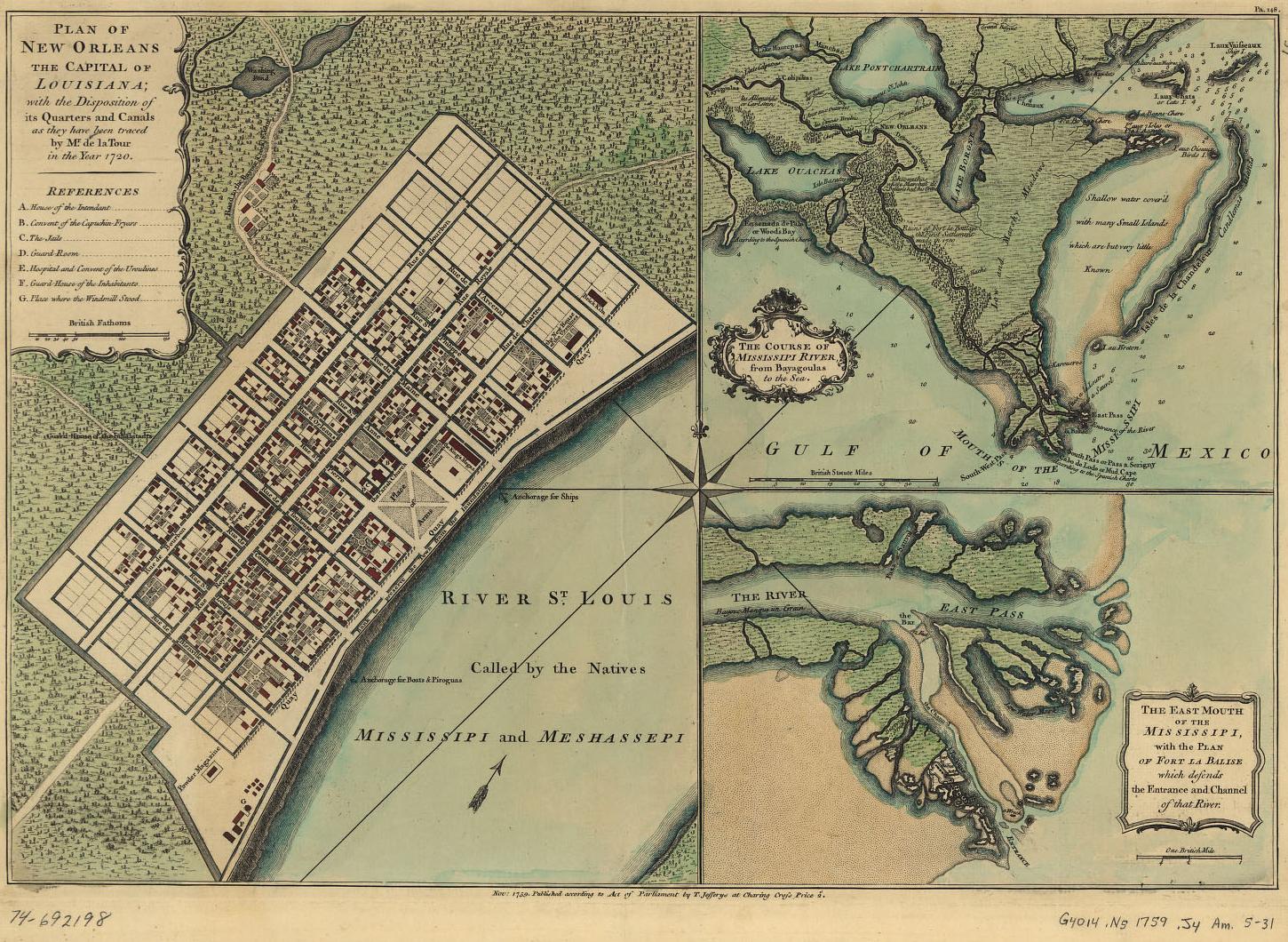
MapsClick Here to hear 'The Lakes of Pontchartrain' recorded by Slainte in 1999 1913 Army Corps Of Engineers chart description 1868Illustrating proposed connections between Lake Pontchartrain and the Mississippi River. Published Army Chief of Engineers Report 1868. Unfolded 13 3/4 x 10 1/2. Color added. It is a map from a report on examination and survey of Pass and Bayou Manchac and AMITE RIVER, with respect to rendering then navigable for First Class Steamboats. 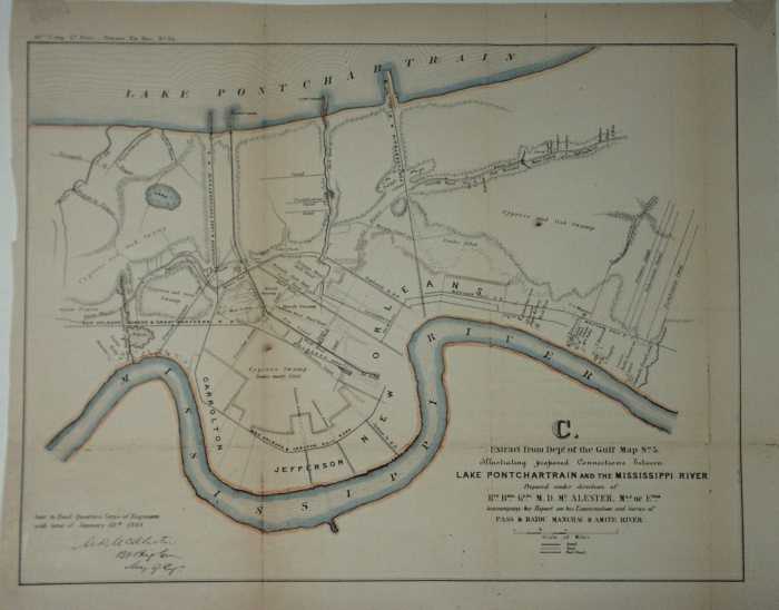 189222 x 15 Color 1892 Map of New Orleans. To the left of the title an example of the two red lines seen in the map which depict the location of the Electric Street Car Lines and the Mule Car lines. In the upper left an insert map depicting a section of the city along Lake Pontchartrain. A few of the interesting notations within the map include; all the Canal locations, Charity Hospital, Rail Road depots with rail company names, the Mint, Confederate Soldiers Home, location of the draining machines, Fair Grounds, US marine Hospital, Work house and the House of refuge to name a few 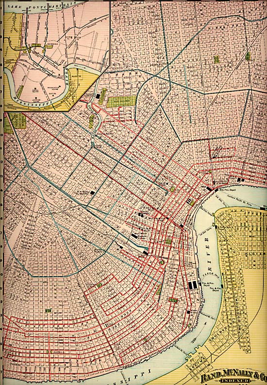 1873 - Plan plan for the redevelopment of the south shoreSource: http://nutrias.org/~nopl/exhibits/ccmem/10.htm This is a detail, showing the West End area, from a remarkable 1873 plan for the redevelopment of the south shore of Lake Pontchartrain in Orleans Parish. The larger plan provides us with several memories: the old, irregular shoreline prior to construction of the seawall, the Spanish Fort amusement park, and the Pontchartrain Railroad pier that allowed the 'Smoky Mary' to take its passengers all the way to the lake. Though never realized, this plan marked the beginning of the planning process that led to the Orleans Levee Board's 1920s reclamation project. [City Archives. Streets Department Records] 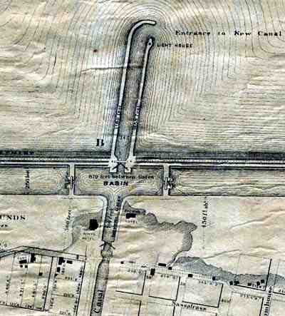 1828 - Plan for canal to connect the River to the LakeSource: http://www.rootsweb.com/~usgenweb/maps/louisiana/citymap/neworleanscanal1828.jpg 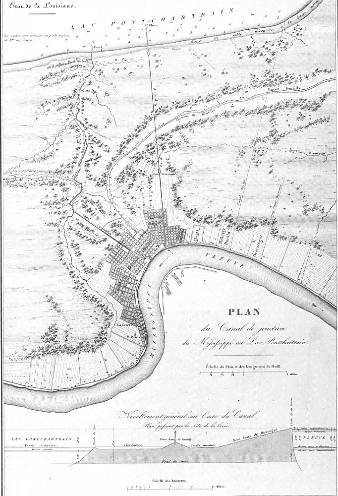 1759
 1768 map shows water route from the Lake to the RiverSource: http://www.rootsweb.com/~usgenweb/maps/louisiana/statemap/lalms1768.jpg 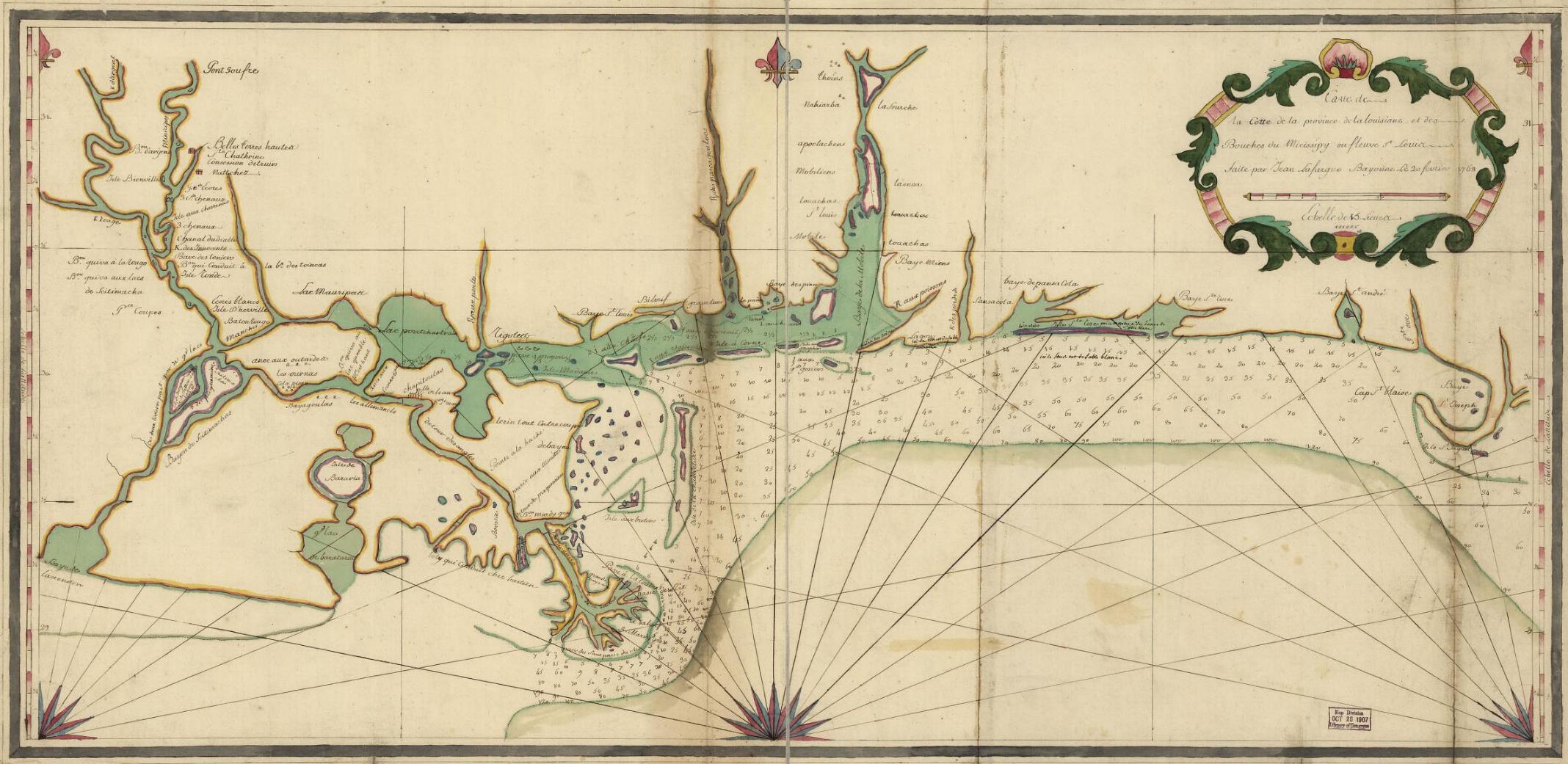 1862 shows Carrolton Railroad Landing, New Canal Light, Fort St. John Light, Milneburg, and Lakeport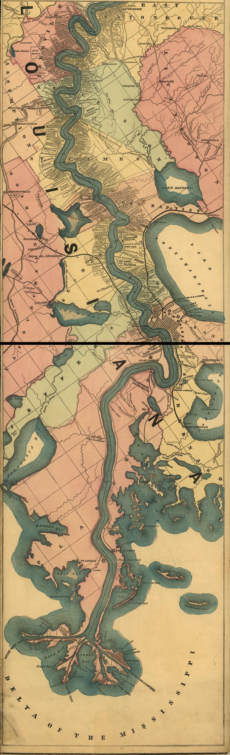 |
|