The Pontchartrain Railroad was the second completed in the United States. It began operation in 1831...
1831 Ponchartrain Railroad (Smoky Mary) is the 2nd in the U.S.
The Pontchartrain Railroad was the second completed in the United States. It began operation in 1831, carrying passengers and goods between the Mississippi River and Lake Pontchartrain in New Orleans
Following an ancient precedent of an Indian portage, there has always been a movement directed to the edge of Lake Pontchartrain. In modern times the first drive towards its navigational advantages and eventually its refreshment and recreation was punctuated in the 1830's by the Pontchartrain Railway to the resort village of Milneburg (along the present Elysian Fields to camps and resorts
Avenue), and the New Basin Canal with its accompanying shell road (replaced by Pontchartrain Expressway).
Source: href="http://lsm.crt.state.la.us/cabildo/cab9a.htm">http://lsm.crt.state.la.us/cabildo/cab9a.htm
1831 Milneburg Grows
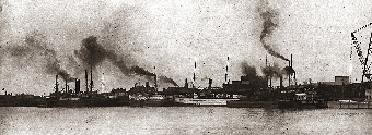
The Pontchartrain Railroad connecting the city of New Orleans with the lakeshore is completed. Because of the railroad, a large resort area develops on the lakeshore at Milneburg. This resort boasts the beautiful Washington Hotel, a park, and a bath building. The Washington Hotel becomes a popular stopping point for travelers while the well-to-do of New Orleans spend pleasant weekends there.
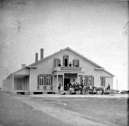
The railroad connected Lake Pontchartrain to the Vieux Carré, (along present-day Elysian Fields Avenue) and developed Milneburg Port at its terminus. While the port handled cargo from Mobile, the surrounding land soon became a resort area, initially with the Lake House tavern and Washington Hotel. Three bathhouses, other hotels and restaurants, camps, and saloons soon followed. Eventually, the name Milneburg connoted a resort area rather than an industrial port.
Photo of the Lake House credit: http://nutrias.org/~nopl/monthly/sept2000/stereo37.htm
1831-1838 New Basin Canal is built
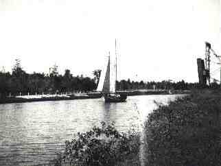
The New Basin Canal is built using Irish immigrant labor, claiming the lives of many men who work on its construction. The canal serves as a transport route between downtown New Orleans and Lake Pontchartrain. Pleasure seekers take a mule-drawn barge, complete with musical entertainment, along the New Basin Canal to the resort at New Lake End (now known as West End).
1830s
The New Basin Canal, which terminated near the present-day site of the Union Passenger Terminal and followed the route now taken by the Pontchartrain Expressway, served as the city's link to the Lake from the 1830s until the 1950s.
Source: New Orleans Public Library--Crescent City Memory Collection
http://www.gnofn.org/~nopl/exhibits/ccmem/2.htm
------
It was built between 1831 and 1838, by Irish immigrant labor, claiming the lives of many men who work on its construction. The canal served as a transport route between downtown New Orleans and Lake Pontchartrain.
Pleasure seekers could take a mule-drawn barge, complete with musical entertainment, along the New Basin Canal to the resort at New Lake End (now known as West End). This quote is from the Save Our Lakes website.
The New Basin Canal, was built by Irish immigrants. The arduous task of digging the canal through alligator and
snake-infested swamps began in 1832. In that same year, a cholera epidemic
hit the city and 6,000 people died in 20 days, many of whom were Irish.
When the canal opened for traffic in 1838, there were 8,000 Irish laborers
who would never see their homes again, having succumbed to cholera and
yellow fever. It was the worst single disaster to befall the Irish in their
entire history in New Orleans.
Ironically, the New Orleans canal and banking company which owned and built
the canal was founded by the aforementioned Maunsel White, and another
Irish-born gentleman, Charles Byrne, was a major shareholder. Financially,
the canal was a success as it opened up trade with communities north of
Lake Pontchartrain and the cities of Biloxi, Mobile, and Pensacola on the
Gulf of Mexico. As the city spread north, finally reaching the lake, its
usefulness began to decline. A fund was established to erect a
monument to the thousands of Irish who lost their lives building it.
Source:http://www.google.com/search?q=cache:AcgX7Jc0_DI:migration.ucc.ie/euromodule/documents/Irish%2520in%2520New%2520Orleans.txt+%22pontchartrain+railroad%22&hl=en
1837 Hurricane Destroys the Bayou St. John Lighthouse
October 6-7, 1837:
Racer's Storm...caused a surge of 8 feet of water above high tide on Lake Pontchartrain...The original wooden Bayou St. John lighthouse, the first built by the U.S. Government outside the original 13 colonies, was swept into obscurity.
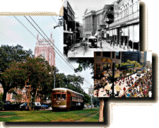
1835 Streetcars beging running
St. Charles Avenue Streetcar Line - An ASME Historic Mechanical Engineering Landmark
Built in 1835, The St. Charles Avenue Streetcar Line is the oldest surviving
interurban-urban passenger rail transportation system in the United States.
Originally incorporated as the New Orleans Carrollton Rail Road in 1833, service
began in 1835. A variety of motive power had been used including horses, mules,
overhead cable, steam engines, and ammonia engines before electrification in
1893. The 900-series cars presently in service were designed and built by the
Perley A. Thomas Car Company of High Point, North Carolina, in 1923 to 1924.
They operate on the original fifteen-mile right-of-way with a 5-foot, 2 l/2-inch
gage track that was adopted in 1929.
Source: http://www.asme.org/history/roster/H101.html
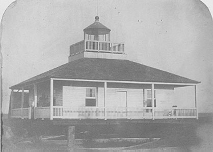
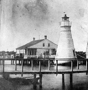
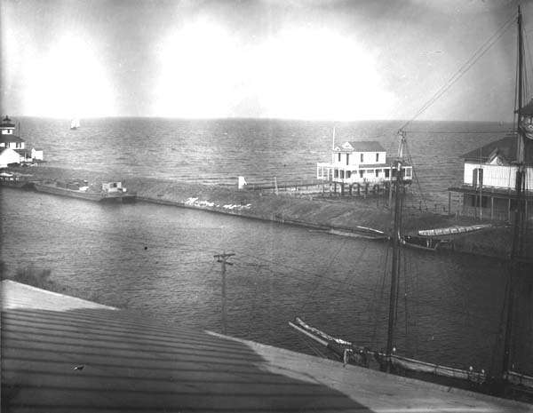
1832 Milneburg-Port Pontchartrain Lighthouse is built
Milneburg Light (also known as the Port Pontchartrain Light)
Located near Elysian Fields Avenue and the lake.
The PORT PONTCHARTRAIN LIGHT (also called the Milneburg Lighthouse) was built in 1832, then replaced
with the existing structure in 1855. It shined until 1929, shortly after Pontchartrain Beach moved from Spanish Fort to Milneburg. It was a memorable landmark in Milneburg when
the area was thriving with entertainment of all sorts. Later the area around the lighthouse became the
Pontchartrain Beach Amusement Park--which old timers refered to as 'Milenburg'. Now the lighthouse is
part of the University of New Orleans Technology Center.
Source: National Maritime Initiative Inventory of Historic Light Stations.
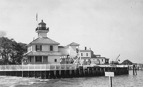
1838 New Canal Light is built
Established in 1838, the
original lighthouse was destroyed and replaced by the existing structure in
1901. It remains active today and the grounds are accessable to the public.
The New Canal Light, was one of a series of octagonal wooden
lighthouses built in 1838, that surrounded Lake Pontchartrain. It was built
on pilings then relocated to its present site in 1910. It was restored in 1976.
Called the 'New Canal Light' because it sat on the edge of the New
Basin Canal--which was covered over during the 1950's and is now West End
Boulevard.
The lighthouse is still operating!
Source: http://www.uscg.mil/hq/g-cp/history/WEBLIGHTHOUSES/newcanal.JPG
1839-The town of Milneburg consists of
a few houses, the Washington and Arch Hotels, a grocery, two barrooms and a bakery. It was named for Alexander Milne, a Scottish philanthropist who owned much of what is now the New Orleans Lakefront.
The Milneburg pier was later built with many camps that could be rented for parties. Black musicians, bands and jazz flourished there.
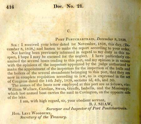
1838 Letter describes Port Pontchartrain (at Milneburg) & lists the boats employed there.
Letter of B. J. Shaw, Surveyor and Inspector of Port Pontchartrain, 3 Dec. 1838
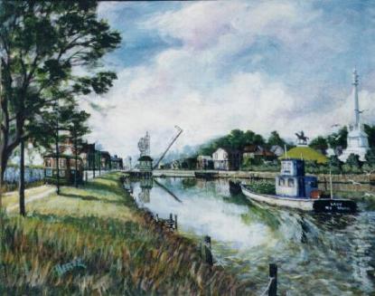
1831 New Basin Canal painting
Builders of the New Basin Canal, which connected the downtown American sector of New Orleans with Lake Pontchartrain, preferred to hire Irishmen because the work was dangerous, and they did not want their valuable slaves injured or killed. Laboring in water up to their hips, canal diggers were very susceptible to yellow fever, malaria, and cholera. Estimates of the number of Irishmen buried along the New Basin Canal ranged from 3,000 to 30,000. Source: http://lsm.crt.state.la.us/museum/education/irish3.htm posted 2002-03-23
1832 This source says that construction of the New Basin Canal was in 1832
The New Basin Canal, was built by Irish immigrants. The arduous task of digging the canal through alligator and snake-infested swamps began in 1832. In that same year, a cholera epidemic hit the city and 6,000 people died in 20 days, many of whom were Irish. When the canal opened for traffic in 1838, there were 8,000 Irish laborers who would never see their homes again, having succumbed to cholera and yellow fever. It was the worst single disaster to befall the Irish in their entire history in New Orleans. Ironically, the New Orleans canal and banking company which owned and built the canal was founded by the aforementioned Maunsel White, and another Irish-born gentleman, Charles Byrne, was a major shareholder. Financially, the canal was a success as it opened up trade with communities north of Lake Pontchartrain and the cities of Biloxi, Mobile, and Pensacola on the Gulf of Mexico. As the city spread north, finally reaching the lake, its usefulness began to decline. A fund was established to erect a monument to the thousands of Irish who lost their lives building it. Source: http://www.google.com/search?q=cache:AcgX7Jc0_DI:migration.ucc.ie/euromodule/documents/Irish%2520in%2520New%2520Orleans.txt+%22pontchartrain+railroad%22&hl=en posted 2002-03-23
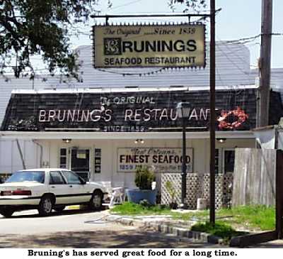
1839 - Brunings Restaurant Opens
The restaurant first opened in 1859, making it one of the oldest (though its run has not been continuous). West End was a very popular resort area in the 1800s and early 1900s. It was a long way out from the populated parts of the city. Going out to West End meant taking a train trip the length of the New Basin Canal. When the canal was closed in, the streetcars stayed, until replaced by buses in the '50s. Bruning's has been a fixture out on West End for well over a century. Source: http://www.yatcom.com/neworl/feature/old/1996/feature_0226.html
posted 2002-04-10
1839 Pontchartrain Railroad Map
Although most transportation in antebellum Louisiana was by water, residents also traveled and traded by overland road and railroad. The Pontchartrain Railroad was the second completed in the United States. It began operation in 1831, carrying passengers and goods between the Mississippi River and Lake Pontchartrain in New Orleans. The Pontchartrain Railroad made Milneburg its lake-end terminal and added to its fame as a resort. Sources: http://lsm.crt.state.la.us/cabildo/cab9a.htm Louisiana Timeline http://enlou.com/time/year1839.htm
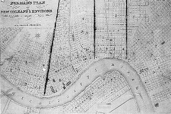
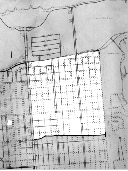
Milneburg map
The white section of this map shows the original city of Milneburg-which was on the Lakeshore before land reclamation projects during the 1920s and 30s.
In 1839 the town of Milneburg consists of a few houses, the Washington and Arch Hotels, a grocery, two barrooms and a bakery. It was named for Alexander Milne, a Scottish philanthropist who owned much of what is now the New Orleans Lakefront. The Milneburg pier was later built with many camps that could be rented for parties. Black musicians, bands and jazz flourished there. Source: Louisiana Timeline http://enlou.com/time/year1839.htm
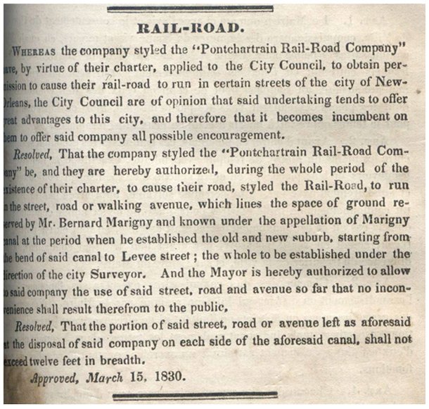
1830 - Pontchartrain Rail-Road Company is chartered
The Conseil de Ville backed up the state-granted charter to the Pontchartrain Railroad by granting permission for the firm to use what we know today as the Elysian Fields Avenue neutral ground. ~ Capital $500,000. President, WCC Claiborne; Secretary, Jno. B. Leefe; Directors Saml W. Oakey, Gaston Brusle, John B B Vignie, A Plicque, E L Bernard, P Guesnon. ~
Length of the Rail Road from the City to Lake Pontchartrain, about five miles--nearly two tracks of rails completed. The company was chartered in 1830. The road was open for business on the 23d April, 1831. The cost of the road has been $500,000. ~
Officers of the Road--General Superintendent, Hartwell Reed; Chief Engineer, Hamon Turner; Local Superintendent city end, W E Proseus, Ticket Seller city end, J Dumangel; Local Superintendent lake end, R Prouty; Ticket Seller lake end, George L. Brown.
~ The Pontchartrain Railroad derived steady income by carrying mail from the city to its terminus on Lake Pontchartrain for transfer to ships that would then carry it on to Mobile. ~
Source: http://nutrias.org/~nopl/exhibits/choochoo/page1.htm
1832 reference to the Pontchartrain Railroad by Buddy Stahl
"Because of the large influx of nonresidents in the French Quarter, New Orleans first transportation system was started.
The fare in 1832 was 12 1/2 cents. The service began with two small, horse-drawn vehicles. The line ran from Canal to Chartres, down Chartres to Jackson Square, then to the cotton presses on Levee Street.
From there it went to the Pontchartrain Railroad depot, located near the river on Elysian Fields Avenue. In a very short time, the service was overloaded, due to the vehicles limited carrying capacity.
The owners of the line resolved the problem almost immediately. The Louisiana Advertiser newspaper ran an article stating that the two small omnibuses were to be replaced. The new vehicles, built by Messrs. Carter of New York, arrived in New Orleans and were hastily put into service on Dec. 19, 1832.
The name given the two were Cotton Plant and Tobacco Plant. Each carried 14 passengers, comfortably seated, and they were each pulled by four horses. Service began at 7 a.m. and stopped at 7:30 p.m. As an additional service to their customers, the omnibuses also carried letter boxes. For the comfort of its female passengers, a sign in each carriage requested that gentlemen not smoke. "
Source: http://clarionherald.org/20010927/stall.htm