- Skip Navigation
- Home
- Amusements
- Art
- Camps
- Facts
- 2nd Railroad in the U.S.
- Elvis was in the building...
- It wasn't originally the Bali Hai
- Jazz was born and bred on the Lake
- Longest continuous curve on U.S. rails
- Over 125 species of fish
- Submarine Races?
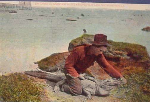
- The $10,000 fish
- The first movie in New Orleans
- The shortest-lived rail ferry services in Louisiana
- Women Lighthouse Keepers
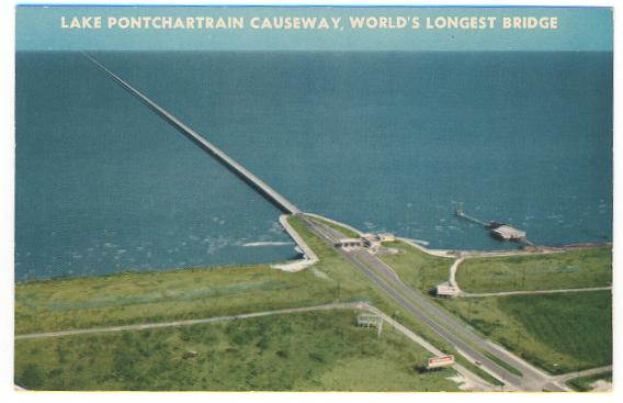
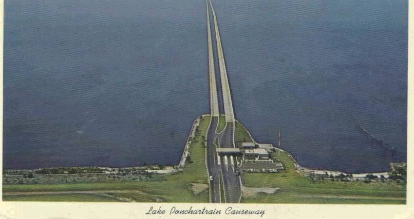
- World's Longest Bridges
- Y.M.G.C. ROWING CLUB
- Get the Pictures
- History
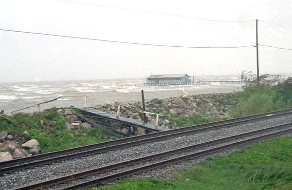
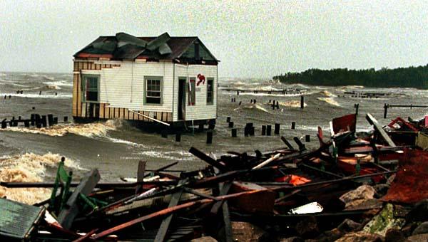
- Hurricanes
- Landmarks
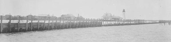
- 1832 to present, Milneburg Light (also known as the Port Pontchartrain Light)
- 1832-1950s - New Basin Canal
- 1833 to present, St. Charles Avenue Streetcar Line - An ASME Historic Mechanical Engineering Landmark
- Bayou St. John
- Pitot House -- National Register of Historic Places
- Pointe Aux Herbes Lighthouse
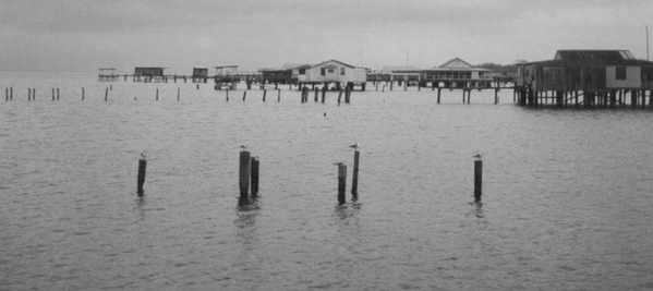
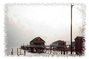
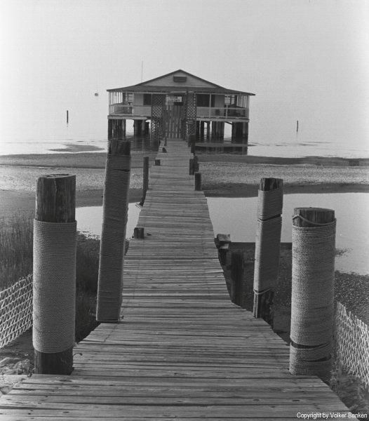
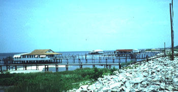
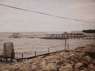
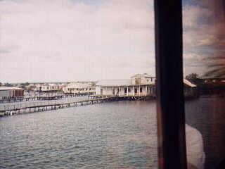
- The Camps
- Literature
- 1841 - The Magnolia of Lake Pontchartrain
- 1852 - Uncle Tom's Cabin
- 1863 - CLARIMONDE: A TALE OF NEW ORLEANS LIFE, AND OF THE PRESENT WAR BY A MEMBER OF THE N. O. WASHINGTON ARTILLERY.
- 1874 - Life On the Mississippi
- 1879 - Four Months in a Sneak-Box
- 1894 - A LADY OF BAYOU ST. JOHN
- 1894 - La Belle Zoraide
- 1897 - A Night in Acadie
- 1897 - Athénaïse
- 1899 - The Goodness of St. Rocque
- 1912 - Social Life in Old New Orleans,
- 1920's & 30's - Mosquitoes and Pylon
- 1946 - Lake Pontchartrain
- 2000 - Crossing Border Street
- Maps
- Military
- Music
- Neighborhoods
- Other N.O. Sites
- The French Quarter's People and Places
- The Nostalgic New Orleans Collection
- Get the Pictures
- Volume 1-ABC
- Volume 2-DEF
- Volume 3-GHI
- Volume 4-JKL
- Volume 5-MNO
- Volume 6-PQR
- Volume 7-STU
- Volume 8-VWX
- Volume 9-YZ
- Contributors
- Lake History
- The Yat Map
- Links
- What is this?
- The Best
- Now & Then
- Feb-Mar
- Today in History
- The 60s
- Art Trivia
- 1879 Illustration from The Nathanial Bishop book Four Months in a Sneakbox.
- Dis is
- Dis is da jacket covuh faw a Robert Tallant book.
- Dis sculptcha is cawled
- Franck Schneider painted this portrait c. 1920s based on an earlier painting by George Catlin.
- Here is an illustration of West End from a book published in 1874.
- Here's a very famous painting of the New Orleans Cotton Exchange in 1873,
- Here's an illustrations called 'WINTER IN THE SOUTH' - for an article in HARPER'S NEW MONTLY MAGAZINE, December 1858.
- High above the Reception Desk, enthroned in a leafy bower, Rex, King of the Carnival and Monarch of Merriment, greets his loyal
- I love this gigantic clarinet. Where is it?
- Illustration from a book published in 1852:
- Krewe of Proteus Float Design circa 1905
- Multicolored Lotus circa 1920 watercolor
- One of my favorite murals in the city. Artist--Tony Green. Where is this?
- The New Orleans Museum of Art is located in City Park at One Collins C. Diboll Circle.
- This sculpture is called 'Serpent Mound'
- This statue is in a New Orleans church. Who's da saint and name da Church?
- This statue, designed by Enrique Alferez, was installed in 1988 on Magazine Street.
- Today we look at some sheet music awt:
- What is this building, where is it located, and what was its' original name?
- Which local hotel is pictured and which artist is featured?
- Who illustrated
- Mr. Lake's Forum
- N. O. Trivia
- A well known writer who came to New Orleans in 1877 was known as 'A Lapidary in Words'
- In May of 1907 Charles C. Mathews opened an amusement park here in the City of New Orleans.
- In May of 1907 Charles C. Mathews opened an amusement park here in the City of New Orleans.
- Joseph Vaccaro, born in Contessa Entellina, Sicily (my own ancestors' stompin' grounds) moved with his parents
- many years ago when something was done backwards, it was colloquially referred to as the 'Belmont Way'. Why
- On March 15, 1729 a ceremony was held for Sister Stanislas Hachard at the Ursuline Convent here in New Orleans.
- This local musician and songwriter secured his place in New Orleans music history with his one and only hit.
- What did it mean when the Falstaff weather ball was flashing red and white?
- What does the word "Tchoupitoulas" mean?
- What is the origin of the word 'stoop'?
- What item was commonly used to scrub stoops in New Orleans?
- What wuzza "TIX Tenna Topper"? Ya hafta git da color an na shape right
- When we think of female movie stars of long ago who hailed from Noo Awlins, we usually think Dorothy Lamour.
- Where was the Third District Ferry landing located?
- Which Roosevelt was the hotel named after?
- Zydeco is an accordian based combination of traditional sounds with rhythm and blues elements.
- Today in New Orleans History
- August 18, 1988 Republican National Convention in the Super Dome
- 1800 Oct. 1, Spain ceded Louisiana to France in a secret treaty.
- 1802 Apr 19, Spain reopened the New Orleans port to American merchants.
- 1803 Dec 20, The Louisiana Purchase was completed
- 1803 Dec 30, The United States took possession of the Louisiana area from France at New Orleans
- 1803- American troops arrive in New Orleans.
- 1803 Declaration...the town of Bayou St. John shall be a port of delivery
- 1803 New Orleanians Become Americans
- 1804 Louisiana Purchase was divided into Territories of
- 1804 - The first English language newspaper in New Orleans
- 1805 Jul 25, Aaron Burr visited New Orleans with plans to establish a new country, with New Orleans as the capital city.
- 1806 Andrew Jackson Duel
- 1806 Norbert Rillieux is Born
- 1812 Louisians Becomes a State
- 1812 The first steamboat arrived in New Orleans
- 1814 - Battle of New Orleans
- 1814 - General Andrew Jackson announces martial law in New Orleans
- 1814 Andrew Jackson Arrives in New Orleans
- 1814 British Use Fireworks in The Battle of New Orleans
- 1814 The Steamboat New Orleans Sinks
- 1815 The Battle of New Orleans
- 1816 -- 1st double decked steamboat, Washington, arrives in New Orleans
- 1816 - Jacques Philippe Villere - Governor
- 1816 The town of Covington is Chartered
- 1818 Garbage Boat
- 1819 Coffee Ad
- 1823 Overcrowded Jails
- 1830 The Pontchartrain Railroad is Chartered
- 1831 - First
- 1831 The Pontchartrain Railroad begins running on what is now the Elysian Fields Avenue neutral ground
- 1832 Schooner Robert Burns Sails to New Orleans
- 1832 The Pontchartrain Railroad
- 1834 Madame Lalaurie's Legend
- 1835 The Medical College of Lousiana Opens--Later Becomes Tulane University
- 1837 A New Jail
- 1839 Debtors Prison
- 1844 - Union Forces Advance toward New Orleans
- 1851 Passenger List
- 1854 The Great State Post Stakes
- 1855 Rematch of at the Metairie Race Track
- 1857 Comus, the god of revelry, became the first New Orleans Mardi Gras parade
- 1860 Fireworks Drive Man Crazy
- 1861 - a
- 1861 - Free Negroes of the City meet and then tender their services to the Confederate Government
- 1862 Gen. Benjamin Beast Butler orders Mrs. Philip Philips imprisoned on Ship Island
- 1862 - Harper's Weekly Illustration
- 1862 - Women's Order
- 1862 Henriette Delille Dies
- 1862 The Capture of New Orleans
- 1862, New Orleans fell to Union forces during Civil War
- 1863 Feux de Joie Aid Confederate Army
- 1863 Governor John M. Parker is Born
- 1864 The New Orleans Tribune, 1st African-American daily newspaper was founded
- 1867 Comus Parade
- 1867 New Orleans dedicated its first synagogue
- 1870 Algiers was annexed as part of New Orleans
- 1870 The New Orleans Pelicans Debut
- 1870 The U.S. governments first simultaneous weather report was made from 23 weather stations across the country-including N.O.
- 1870 Twelfth Night Revelers - 2nd N.O. Carnival Krewe
- 1876 NOLTC is the countrys first lawn tennis club
- 1876 Rayne Memorial United Methodist Church
- 1877 Federal troops were ordered out of New Orleans, ending the North's post-Civil War rule in the South.
- 1878 J. F. Doescher opens Lutheran Sunday school for Negroes
- 1884 Oscar Papa Celestine is born
- 1887 The N.O. The Pelicans make their professional debut
- 1889 - Death of Confederate President Jefferson Finis Davis
- 1889 David C. Hennessey becomes the citys first Superintendent of Police
- 1890 Superintendent of Police, David C. Hennessey is Murdered
- 1892 Sullivan vs Corbett Fight
- 1893 The Longest Prizefight in History
- 1896 Plessy vs. Ferguson
- 1896 First Movie in New Orleans
- 1896 First Movie Theater in the United States
- 1897 Sidney Bechet is Born -- and died on his 62nd Birthday in 1959
- 1897 The Great Steamboat Race
- 1898 - McDonogh Monument is Dedicated
- 1898 Gustave Joseph (Sharkey) Bonano is Born
- 1903 United Confederate Veterans Reunion
- 1909 - Robert Tallant is Born
- 1909 Danny Barker was born
- 1909 Napoleon's Death Mask...
- 1910 - Moisant vs. a Packard
- 1911 - Hubert Humphrey (LSU graduate and Vice-President) is born.
- 1911 Mahalia Jackson is Born
- 1911 Mahalia Jackson was born
- 1912 USS South Carolina in New Orleans
- 1913 Storyville
- 1914 - Dorothy Lamour was Born
- 1914 Kitty Carlisle is born in New Orleans
- 1915 Pelican Stadium Opens
- 1915 Storm
- 1920 The Desire streetcar began operating
- 1921 - 24 ton Hibernia Bank vault door
- 1924 - Lee Dorsey is Born
- 1925 -- Roy James Brown Was Born
- 1925 Pulitzer Brothers Begin a Tie Empire
- 1927 -- Charles Lindbergh, flew the Spirit of St. Louis into Alvin Callender Field
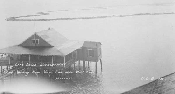
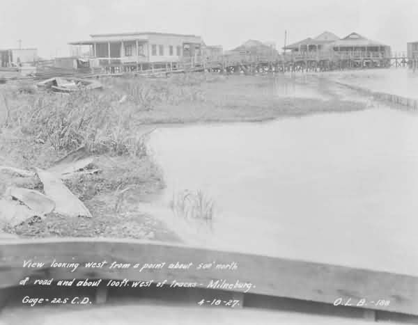
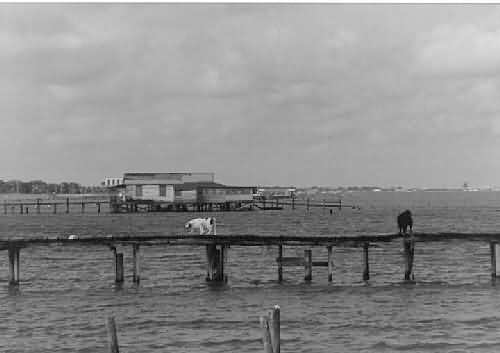
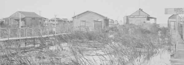
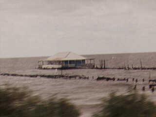
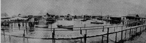
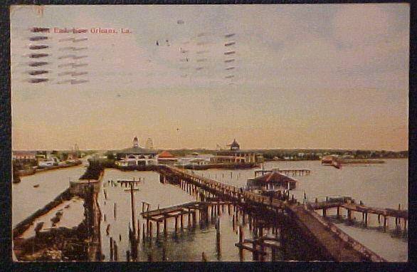
- 1927 Milneburg Camps (now UNO area)
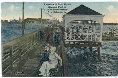
- 1928 The first Pontchartrain Beach at Spanish Fort
- 1928 World's Longest Bridge
- 1929 Streetcar Strike
- 1930 The First Coffee Break
- 1931 First Night Game Played at Tiger Stadium
- 1932 The Smokey Mary makes its' last trip to Milneburg
- 1933 The National Bank of Commerce
- 1934 Lodge No. 30 of the Benevolent and Protective Order of Elks Approve the Idea of a Truck Parade for Mardi Gras
- 1934 Mayor of New Orleans Big Police Force ready to do battle with Senator Huey P. Longs Guardsmen
- 1935 - The Bonnet Carre Spillway is Dedicated
- 1935 - The Huey P. Long Bridge is Dedicated
- 1935 Huey P. Long Bridge Dedication
- 1937 - FDR in New Orleans
- 1937 - Legal documents bound by WPA Bookbinding Project.
- 1937 Lagoon Bridge (City Park)
- 1937 New Orleans Item Political Cartoon,
- 1938 Allen Toussaint was born
- 1938 Fascism or Freedom
- 1939 -- Fire Station #1 at Elysian Fields and Pelopidas St.
- 1939 Robert E. Lee Blvd. Bridge
- 1939 Oretha Castle Haley is Born
- 1940 - St. Mark's Community Center
- 1940 Dr. John (born Malcolm Rebennack, aka Mac Rebennack) is Born
- 1940 Duke Ellington Records Ko-Ko
- 1940 WPA Bookbinding Project
- 1941 Linclon Beach
- 1941 Pontchartrain Beach
- 1941 Pontchartrain Beach
- 1942 Air Raid Warning Truck
- 1944 West End Street Car
- 1946 Chep Morrison Inauguration
- 1948 - WDSU TV Channel 6 in New Orleans begins broadcasting.
- 1948. The Desire Streetcar Ceases Operation
- 1952 De La Salle High School is Officially Dedicated
- 1952 Evarts Ambrose Graham Dies
- 1952 The Falstaff Weather Ball is First Lit
- 1953 Homer Plessy is Born
- 1954 - The new Union Railroad Station opens
- 1954 Oscar
- 1956 - Daniel Mukes, traditional jazz snare drummer from New Orleans, Louisiana died
- 1956 -- John F. Kennedy at the Roosevelt Hotel
- 1956 Lake Pontchartrain Causeway Opens
- 1956 Audubon Park Fishing rodeo
- 1957 Pelican Stadium Closes
- 1960 - Gov. Davis seeks funding for private education
- 1960 - Jimmie Davis is elected governor
- 1960 Jessie Hill recorded Ooh Poo Pah Doo
- 1961 Ernie K-Doe's Mother-In-Law hits the Billboard Charts
- 1961 Imprisonment for debt is abolished legally in Louisiana
- 1962 New Orleans Citizens Committee gave a free one-way ride to blacks to move North.
- 1962 Archbishop Joseph Francis Rummel ordered all Roman Catholic schools in the New Orleans diocese to end segregation.
- 1962 Vic Schiro's Inauguration
- 1963 - Tidelands Officially Deeded
- 1964 - Louis Armstrong hit the top of the pop charts for the first time in his career with
- 1964 Mayor Morrison's Funeral
- 1965 - Joe Rotis, traditional jazz trombonist, dies
- 1967 Mayor Schiro confers with his legislative leaders
- 1967 Saints launched their first season-ticket drive
- 1967 The Notorious Riverfront Expressway
- 1967 Vic Schiro and Alton Ochsner
- 1968 - Christopher 'Black Happy' Goldston, traditional jazz drummer from New Orleans, Louisiana died
- 1968 Scoop Kennedy's Birthday
- 1969 Fire on Oak Street
- 1970 the Doors made their last appearance with Jim Morrison.
- 1971 Louis Armstrong Dies
- 1972 - Lous Saint at WTIX Radio
- 1972 Mahalia Jackson Dies
- 1973 Mardi Gras
- 1976 Times-Picayune Article About Pralines
- 1978 - Harold Cooper died
- 1980 - The New Orleans Saints end their 14 game losing streak
- 1981 Oliver Alcorn Dies
- 1983 Sweet Emma Barrett Dies
- 1989 - Deep Cold in the Deep South
- 1989 - New Orleans native Bobby 'I'm Gonna Be A Wheel Someday' Mitchell passed away at the age of 53, on this day.
- 1989 Professor Longhair (born Henry Roeland Byrd) Dies
- 1993 The Pelican Brief
- 1994 Danny Barker Passes Away
- 1997 Our Mother of Perpetual Help Chapel
- 1997 Termites threaten New Orleans' treasures
- Apr 11, 1713 The French colony of Acadia was ceded to Great Britain
- April 1, 1778 Oliver Pollock created the $ sign
- April 1, 1778 Oliver Pollock created the dollar sign
- April 15, 1958 Greater New Orleans Bridge opening
- April 15, 1958 Greater New Orleans Bridge opening
- April 27, 1999 Al Hirt, Dies
- April 4, 1812 The Territory of Orleans admitted to the Union
- April 4, 1812 The territory of Orleans became the 18th state
- April 8, 1812 Louisiana Territory become Missouri Territory
- April 9, 1682 La Salle discovers New Orleans
- Aug 25, 1718 Hundreds of French colonists arrived in Louisiana
- Aug. 7, 1727 Ursaline Nuns Arrive in New Orleans
- August 4, 1901 Louis Armstrong was born
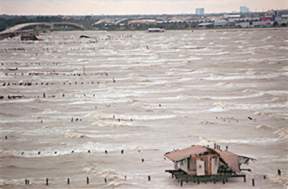
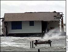
- August 17, 1969 Hurricane Camille
- August 18, 2000 Dorothy Mae Delavallade Taylor Dies
- August 25, 1718 City of New Orleans founded
- August 25, 1718 City of New Orleans founded
- August 25-26, 1992 Hurricane Andrew
- August 29, 2005 Hurricane Katrina
- August 3, 1975 Superdome (New Orleans) opened.
- Benjamin F. Butler, U.S. Civil War General, died on this day in 1893
- Comic performer Ellen DeGeneres was born on this day in 1958 in New Orleans.
- December 10, 1914 Dorothy Lamour is born .
- December 20, 1802 U.S. purchases Louisiana Territory
- December 23, 1794 - Cathedral Dedicated
- December 27, 1741 - Jean Etienne Bore is Born
- December 31, 1910 - John B. Moisant Crashes
- December 31, 1910 John B. Moisant Crashes
- December 7, 1861 CSS Pamlico
- December 7, 1978 The Falstaff Weather Ball Goes Dark
- Feb. 1, 1700 First Buildings
- Feb. 16, 1811 Territory of Orleans Constitutional Convention
- Feb. 27, 1979 Mardi Gras cancelled due to New Orleans Police strike
- February 1, 1937 Garrett Morriss is born
- February 25, 1964 Eastern flight 304 crashes in Lake Pontchartrain
- February 27, 1827
- February 27, 1949 - New Orleans Wedding
- February 28, 1849 - The Odd Fellows Dedicate Their New Cemetary
- February 8, 1922 Ground Breaking for the Notre Dame Seminary
- January 1
- January 31, 1752 First American Nun
- January 7-8, 1973 Howard Johnson sniper (Mark Essex) incident
- Jayne Mansfield died in an automobile, on her way from Biloxi to New Orleans - June 29, 1967
- Jazz clarinetist Pete Fountain was born on July 3, 1930 in New Orleans
- Jazz singer Fats Domino was born on this day in New Orleans in 1928.
- Jazz trumpeter Al Hirt was born on this day in 1922 in New Orleans.
- July 10, 1941- Air Training Base Project
- July 11, 1938 Mayor Maestri on a WPA Project Tour
- July 12, 1965 Schiro Fourth Anniversary celebration
- July 15, 1941 Navy Air Training Base commissioned
- July 2, 1955 Road Construction
- July 24, 1940 - Federal Music Project
- July 25, 1968 - Maison Blanche Fire
- July 31, 1936 - St. Roch Playground
- July 9, 1982 Airplane crash (PanAm flight 759) in Kenner
- June 10, 1937 Pontalba Buildings Renovation
- June 11, 1955 Jockey Club House
- June 12, 1967 - New Orleans Fire Department
- June 13, 1870 - Check written by Benjamin Keyes Fawcett
- June 14, 1999 - Al Gore in New Orleans
- June 15, 1881 Marie Laveau Dies
- June 17, 1911- The Milneburg Playground
- June 18, 1955 Ruins of house where Pakenham died
- June 19, 1909, The chartering of Greater New Orleans Homestead
- June 2, 1938 - New City Park Bridge
- June 20, 1953 - 600 block of St. Peter Street
- June 21, 1937 - Rural Letter Carriers' Convention
- June 22, 1905 George Moore | Burglar |
- June 23, 1973 Jimani/Upstairs Lounge fire
- June 25, 1955 St. Patrick's Church
- June 26, 1910 St. Roch Playground Opens
- June 27, 1939 Charity Hospital tunnel
- June 28, 1957 Hurricane Audrey
- June 3 - Confederate Memorial Day
- June 6, 1939 - Firestation Construction at Elysian Fields and Pelopidas
- June 7, 1981 St. Roch Swimming Pool dedication
- June 9, 1939 - American Legion-WPA baseball team at City Park.
- Juy 14, 1955 Bob Hope in New Orleans
- March 13, 1998 Risen Star Dies
- March 17, 1884 - Alcide 'Yellow' Nunez is born
- March 2, 1699 Sieur De Iberville Finds the Mouth of the Mississippi
- March 20, 1687 Cavalier Sieur De La Salle is Assassinated
- March 21, 1788 Almost the entire city was destroyed by fire
- March 21, 1788 The Good Friday Fire
- March 29, 1721 Governor Bienville choses site of New Orleans
- March 30, 1967 Airplane crash at Airport Hilton in Kenner
- March 5,1766 Spanish official Don Antonio de Ulloa
- March 9, 1699 Indians lead Iberville & Bienville to Bayou St. John
- May 1, 1995 - Harrah's New Orleans Casino grand opening
- May 11, 1988 Cabildo fire
- May 12, 1984 Louisiana World Exposition (World's Fair) opening day
- May 3, 1978 Extensive street flooding in New Orleans
- May 31, 1958 Race screens are removed from NOPSI buses
- May 8, 1995 Extensive street flooding in New Orleans
- November 25, 1947 John Laroquette is born in New Orleans
- November 29, 1972 Rault Center fire
- October 1, 1811First steamboat reached New Orleans viâ the Mississippi
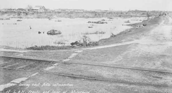
- October 10, 1923 Milneburg (Before and After)
- October 12, 1844 George Washington Cable is born
- October 16, 1972 Disappearance of Hale Boggs
- October 18, 1961 Wynton Marsalis was born in New Orleans
- October 28, 1768 Germans and Acadians join French Creoles
- October 31,1803 Congress ratified the purchase of Louisiana
- October 5, 1799 First Greek church wedding in New Orleans
- On this day in 1933, a barge towed from New Orleans arrived in Chicago, the first to go from the Great Lakes to the Gulf.
- One of the coldest days on record
- Pontchartrain Beach Amusement Park's last day of rides--September 25, 1983
- Republican convention in New Orleans
- Richard Simmons & Jay Thomas are born in New Orleans
- September 1, 1990 Aquarium of the Americas grand opening
- September 11, 1722 First Recorded Hurricane
- September 11, 1965 Flood Street Photo -- Aftermath of Hurricane Betsy
- September 11-13, 1987 Papal visit (Pope John Paul II)
- September 16, 1964 The Beatles perform in City Park Stadium
- September 28, 1998 Hurricane Georges
- September 9, 1965 Hurricane Betsy
- Shirley Ann Grau was born
- Singer and jazz pianist Harry Connick, Jr., was born on this day in 1967 in New Orleans.
- St. Joseph's Day
- The Battle of New Orleans of the War of 1812 was fought on this day in 1814
- The Cleveland Playground at Tulane and South Claiborne opens
- The first double-decker steamboat, the Washington, to reach New Orleans did so on this day in 1816.
- The first permanent Roman Catholic convent in America was opened on this day in 1726 in New Orleans.
- The first steamboat on the Mississippi River at New Orleans, Jan. 10, 1812
- Truman Capote is Born
- Venetian blinds were patented by John Hampson in New Orleans in 1841.
- WPA Project Tour, June 24, 1938
- WTIX Music Survey- June 8, 1974
- People
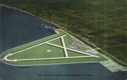
- Ports & Harbors
- Pre-History
- Resources
- Sources
- Historic American Buildings--American Memory-Library of Congress
- Louisiana State Museum
- Louisiana State Museum
- Mark Twain's Illustrataions
- New Oleans Online-Culture
- New Orleans Public Library
- Pierre LeMoyne Sieur d'Iberville--Discoverer of the Mississippi
- Project Gutenburg
- The Historical Hightlights of the Lake Pontchartrain Basin
- Student Activities
- Thanks
- Sources
- Restaurants
- Site Map
- Stories
- The Book
- Transportation
- Photo Albums
- Contact Us
New Orleans History -- Lake Pontchartrain
Friday, July 11, 2025